
Guest post by Casey Moran from the Hartford Livable Coalition. See also part two about Hartford’s section and safe routes to schools on the Hartford Livable Coalition website. Also, learn more about the East Coast Greenway (connecting Maine to Florida) and the proposed HartLine Trail (connecting Bloomfield and downtown Hartford).
Update: Read about Tri-Point Greenway Planning Grant, March 2024
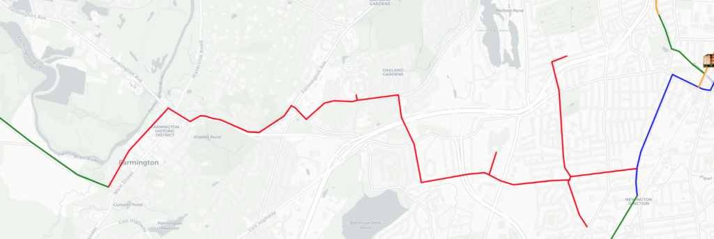
Connecticut’s Southern Capital Region is on the cusp of something truly magical, the establishment of a world class greenway connecting West Hartford, Hartford, New Britain and the Farmington Canal Trail at Plainville by linking a series of multi-use trails together in a concept I will call the Tri-Point Greenway. It is imperative to close the missing remaining gaps, the Elmwood Gap in West Hartford and the South Branch gap in Hartford to achieve this vision. Explore the Tri-Point Greenway interactive concept map (updated March 2024)
What is a Greenway anyway?
A greenway is an active-transportation corridor that allows residents and visitors to move around on foot, in wheelchairs, on bikes or any non-motorized method, safely protected from automobiles and trucks. While greenways provide space for recreation, that is not the primary goal, they instead aim to connect people with places and are especially critical resources in densely populated areas. The envisioned Tri-Point Greenway would mean 85,000 Nutmeggers live within walking distance to one of its component trails.
Greenways benefit from network effects of combining individual isolated trails into a system. People want to go from home to school, the grocery store, friends’ houses, parks, recreation sites, restaurants, retail stores, and work. A regional greenway enables that to happen and has the major benefit of allowing families to mode shift towards cheaper and more environmentally friendly modes of transport. An isolated or short-distance trail is simply not utilized the way a greenway is.
Just how close is the Tri-Point Greenway to existing?
Let us look at the Southern Capital Region’s trail network, inclusive of currently in-flight projects.
We are 3.5 miles from having a fully connected greenway safely enabling car free travel in and between Hartford, West Hartford, Newington, and New Britain. We are 3.5 miles from connecting Hartford and West Hartford safely to the East Coast Greenway at Plainville. We have already created a near-complete route through diverse towns and neighborhoods to connect to each other, to resources, rather than a far-off strip of land away from where people live and work and play. There are only three remaining gaps that remain unplanned but are necessary to complete the Capital Region Tri-Point Greenway, they are:
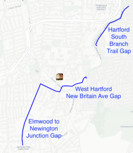
1. Hartford South Branch Trail Gap
1.1 miles from Pope Park to Flatbush Avenue along the South Branch of the Park River in Hartford running along Brookfield Street. This is currently a low-stress wide road with unprotected bike lanes and shoulders.
2. West Hartford New Britain Avenue Gap
0.8 miles from Newfield Avenue to New Park Avenue along the South Branch of the Park River and Trout Brook in West Hartford. This is presently an extremely high-stress state road without shoulders.
3. Elmwood to Newington Junction Gap
1.5 miles from New Park Avenue in West Hartford to W. Hill Road in Newington along Newington Road and Willard Avenue. This is presently a high-stress state road without shoulders or continuous sidewalks.
If these gaps were closed, the Southern Capital Region would have a continuous safe greenway network with over 85,000 residents living within easy walking distance of this Tri-point Greenway from New Britain up through Elmwood to West Hartford and Hartford. A remarkable number!
Building on Momentum to Connect more Destinations
While closing the Tri-Point Greenway’s gaps should be priority number one for the southern region’s trail network, it is important also to look toward what future connections can be made to expand the usefulness of the Greenway. Just to the west of the Tri-Point Greenway in West Hartford is (in order) the Wolcott Neighborhood with multiple schools, West Farms Mall and other retail stores, UCONN Health, Farmington Center, and the Farmington Canal Trail in incremental distances of 1-2 miles. By routing the Tri-Point Greenway down Newington Ave/Willard Road, there would be easy access to the existing utility right-of-way to easily connect to all of these major demand point connections. Remember: Greenways are networks, the bigger the network becomes the more useful it is, the more people will use it.
Everyone Deserves Access to a Great Greenway
For those who have yet to enjoy one, greenways are truly a thing of magic. Imagine a steady stream of residents going about their daily business: a teen walking to get coffee with a friend, a nurse making it home from work on a sunny afternoon, a parent rolling to pick up groceries on their cargo bike, grandparents picking up their grandkids from school. Overlapping trip origins and destinations will keep the trail busy and safe encouraged by a seamless integration with the street grid – this will surely become a treasured community asset. If you want to see the magic in action, take a look at Manhattan’s Hudson river front, Boston’s Charles River park network, many segments of the Farmington Canal Trail, or Atlanta’s Beltline. Imagine if we had one right here that was right out your front door? That is a future worth getting excited for.